Zapt Tech

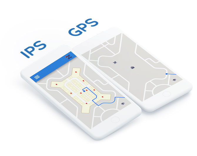
Indoor Positioning (Blue-Dot)

Our IPS technology (the “GPS Indoor”) provides real-time location in covered spaces with high performance, stability and accuracy of 3 meters, enough to display complementary information about what is in sight of the customer, without clicks!

Indoor Navigation (Wayfinding)

Our navigation technology traces instant routes from the current location to selected destinations, guiding with very high usability: by text and voice, in an integrated way with physical signage, with maps rotatable and in perspective, across multiple floors, among other top-of-the-line features.

Playful and Tourist Maps (Walking Maps)

Bring underused architectural and print plans to life, transforming them into useful, interactive maps. Our positioning and navigation technology works on playful, illustrated and tourist maps, optimized to engage pedestrians during their shopping and business, tourism or leisure visits.

Guided Tour (Waypoint Navigation)

Establish pre-defined routes with multiple stops and audio guidance to guide customers through highlights, tourist routes, related purchases (eg ingredients for recipes ), among others. Our “Audio Guide” technology turns devices into real tour guides or shopping assistants.

Proximity Marketing (Geofencing)

Provide promotions, offers and relevant information that change as you navigate through sections of the place.

Analytical Visitation Data (Big-Data)

Zapt Tech's people tracking technologies, based on WiFi and Bluetooth, collect visitation flows even for “non-users” of the application, generating statistics and a map valuable heat for improving layouts and monitoring promotional campaigns.

Voice Assistant

Search for products, services, attractions, stores and spaces speaking naturally. Receive information and guidance by text and audio.

Cards, Categories and Tags

Register information cards for Points of Interest and organize them into categories, using different tags to cover the most diverse forms of search used by customers, by voice or typing .

Interactive Totems

Make interactive totems available with the Route Preview service, integrated and sharing the same updates as the applications.

Location Based Services

Knowing the precise location of customers in a physical location enables a wide range of previously impossible services such as “sending offers at the right time and place”, “segmentation of profiles according to visitation routes”, “transactions without clicks, by mere proximity”, “playful experiences as augmented reality in the style 'Pokémon Go Indoor' ”, among others. Consult Zapt to develop location-based services!
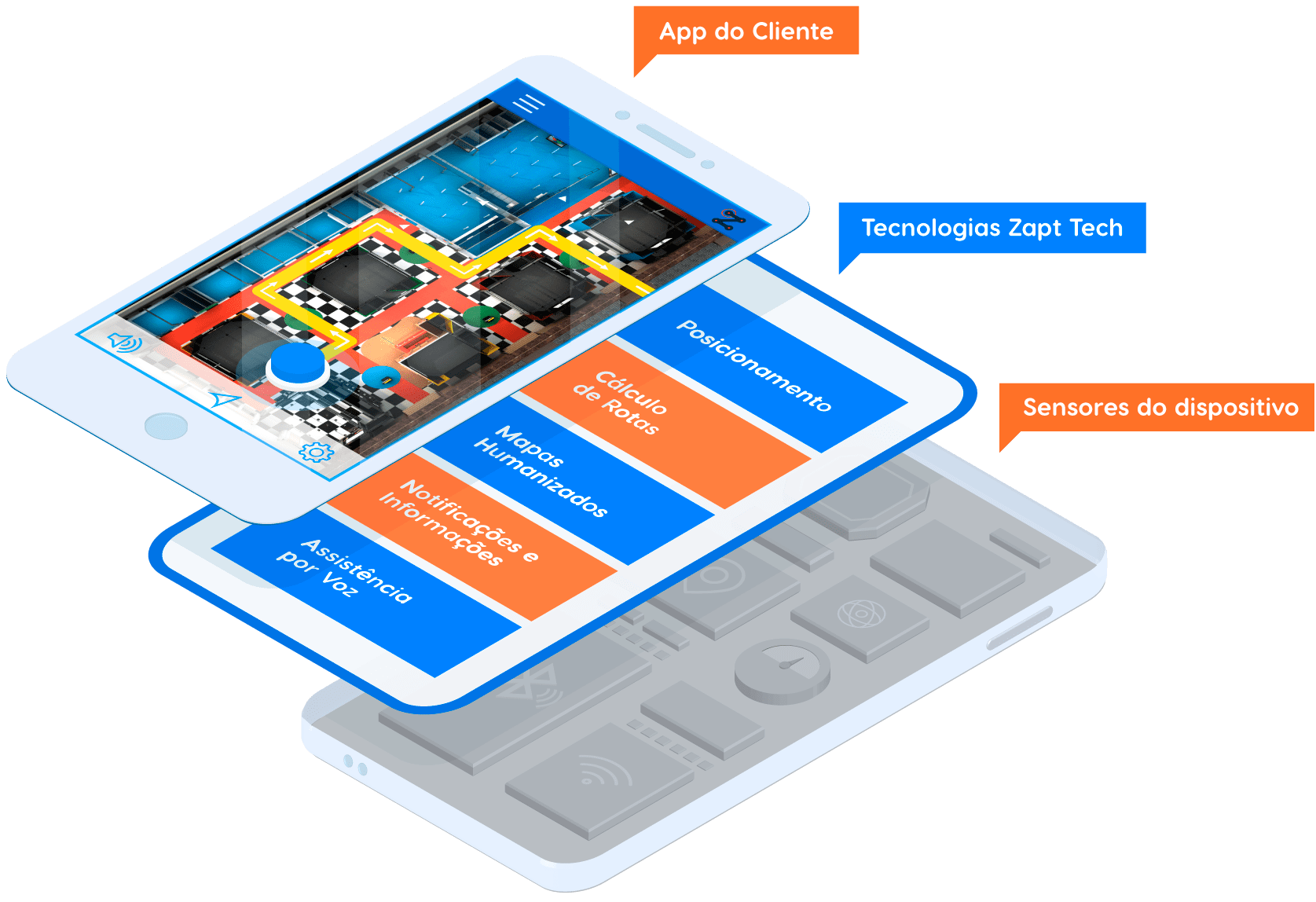
Feature-rich ...

Automatic exchange of maps (indoor-outdoor and between floors); multi-language; multi-location (the same app serves several physical locations or events); multi-beacons (beacons, WiFi, GPS); online and offline operation; etc.

Flexibility for Availability

All of these resources can be made available in an app with the customer's identity / brand in white-label mode; or so integrated into existing applications via SDK;

Your first step on The Internet of Things

Zapt Tech's disruptive technologies transform conventional venues into 21st-century smart environments that are able to guide, inform and deliver services to their customers and visitors in a completely innovative way.

Indoor Positioning System (IPS)

Flexible Positioning Algorithms in Indoor Locations

GPS-based signals and locators do not work indoors due to either complete lack of signal or inaccuracy.

Even when supported by Wi-Fi signals and carrier antennas, conventional GPS-based browsers such as Google Maps, Apple Maps or Waze can be instable and display gross precision errors, in some cases up to 30 meters, in indoor locations.

If that were not enough, it operates on the same maps designed for automotive vehicles, unsuitable for pedestrians.

You have arrived at your destination. I wonder.

Zapt finishes what GPS navigators merely started... After all, your final destination is not a street in the vicinity of the destination address but a seat in one of the auditoriums of a hotel, a meeting room in one of the buildings of a corporate headquarters or a piece of equipment inside a factory.

In order to correct this limitation of current positioning systems, Zapt has developed flexible algorithms and configuration models which enable accuracy of up to 2 x 2 meters in any enclosed space.

With this level of quality, patrons of Zapt-configured locations can pinpoint themselves, get instant information about products and services at their fingertips and, upon selection, can be guided via the quickest route to any product, service or point of interest, even in between floors and buildings.

All this on humanized maps appropriate for pedestrians.

Proximity Transactions

Contactless transactions via Messages, Information Cards and Services.

Corporate headquarters, industrial plants, hospitals, airport terminals, bus terminals and railway stations, shopping malls, municipal fairs, museums, stadiums, exhibition halls, resorts, large hotels, training venues, clubs and university campuses are just a few examples of complex venues with a large influx of customers and / or visitors and tourists, who can immediately benefit from Zapt's positioning and orientation features.

But that's not all: by knowing the exact position of your customers and visitors, a "smart spot" opens up a huge range of possibilities for streamlining processes and delivery service innovation through Contactless Transactions.

Just a few examples

Promotional messages with "upcoming" offers can be sent, even if the user has their cell phone locked and in his or her pocket.

When going through a box office, display or showcase with a promotion, a card can be displayed "by mere proximity" with the offer of immediate employment of that specific service, be it purchasing a ticket, product or paying for parking.

In some cases, a client simply entering or exiting defined areas can activate an automated transaction, which can be easily recognized as an "uberization of services in general", in relation to the “zero-effort” payment model popularized by Uber.

Touristic & Humanized Maps

Positioning Algorithms in Outdoor Locations on Humanized & Tourist Maps.

Zapt Tech algorithms also stand out in complex outdoor areas with a large number of services, points of interest and pedestrian flow: the same services typical of GPS navigators can be provided on humanized or tourist maps, artistically disproportionate and especially suitable for on-foot exploration.

New maps do not need to be made... Zapt gives life to any existing map.

Frequently Asked Questions

Got it. But How Soon Can I Launch Orientation Services and Proximity Transactions?

The typical setup time for converting from conventional locations to Zapt smart locations ranges from a few days, a few weeks, to a maximum of a few months in the most complex scenarios, depending on the following factors:

  • Completely open-air locations (e.g. zoos, amusement parks or exhibition parks, tourist sectors): between 2 to 10 days, typically depending on the size.
  • Fully indoor/covered locations (e.g. covered museums, hospitals, exhibition halls): between 5 to 30 days, typically depending on the number of floors and total square meters to be covered.
  • Hybrid locations (e.g., resorts, university campuses): these are the most complex places, composed of an open map with the overview and several maps for the floors of the various building. However, the flexible algorithms of Zapt allow configurations of this size between 20 and 60 days, typically.

How Much Would My Investment Be?

In addition to the initial setup, the final investment in a Zapt solution may include costs for making maps, information cards, and the app for guidance, location, and proximity transactions. The final investment depends on the following factors:

  • Do you already have digital files with all the maps, in PNG, JPG, DWG or SVG format? If not, the content creation area of Zapt Tech can create engaging and humanized maps.
  • Do you already have photos and summarized content for all points of interest, promotions, etc.? This is an eminently internal job of the organization, but information on websites or digital files can be extracted by Zapt to expedite its availability.
  • Do you intend to use the Zapt App? Zapt is (and always will be) a free app for end users, instantly available on iOS and Android. Zapt is personalized, with colors and functionalities and can vary according to the location of the user. Using the Zapt App is the primary cost-saving factor, eliminating the investment needed to create or maintain apps using Zapt technologies via the SDK.

Cutting-edge solutions: In any scenario, Zapt guarantees the quality and maintains location and transaction results of over time, providing the necessary quantity of sensors according to each case, revising configuration according to layout changes and even updating maps and cards, upon request by the client.

Contact us to learn how Zapt can benefit your business

Your message was submitted succesfully

Thank you for your contact.
As soon as possible we'll get back to you.

Reload form.
Top